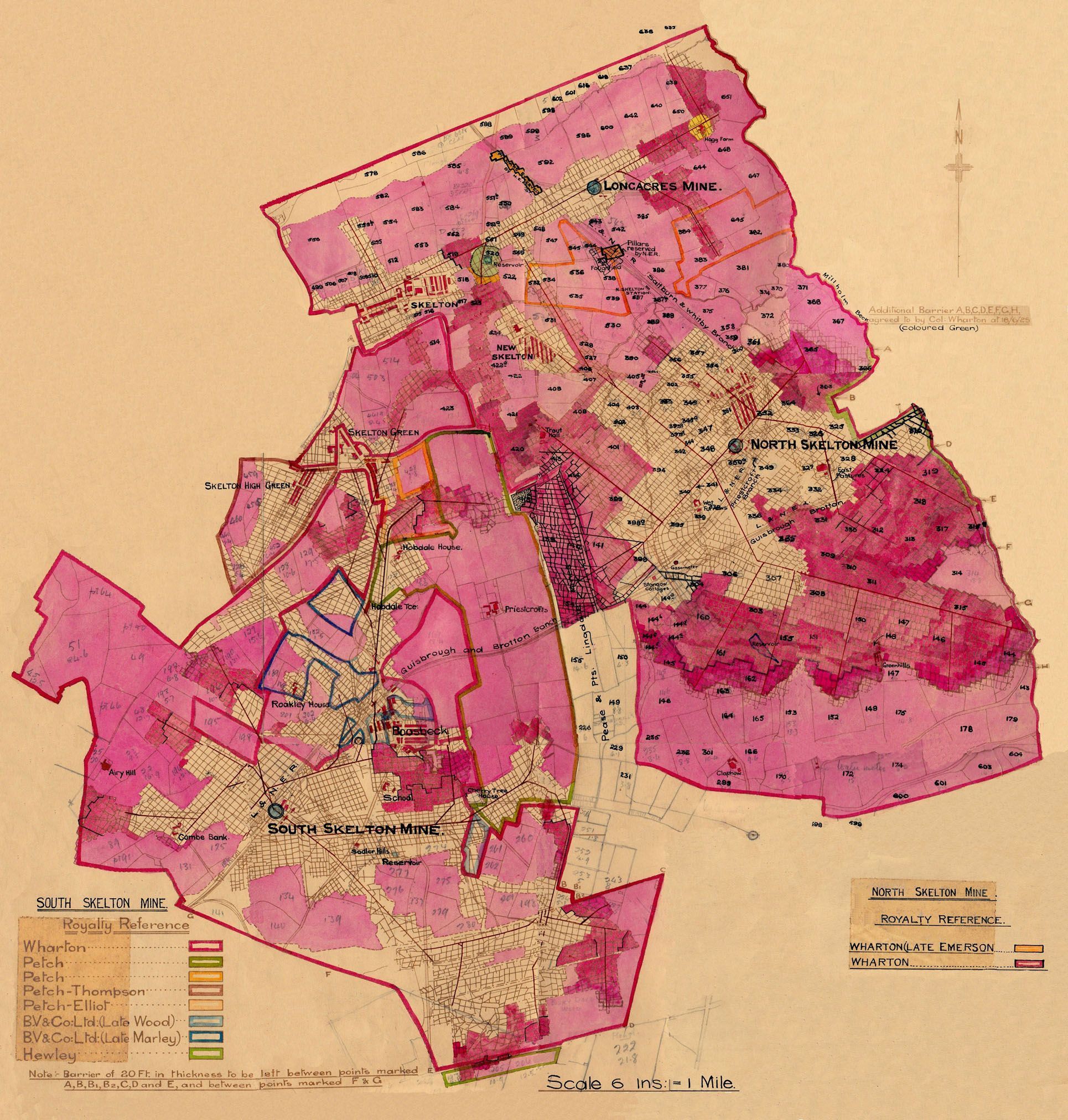
Map of North and South Skelton Ironstone Mines about 1925.
|

Kevin Ward.
|
The map below has been kindly contributed by Kevin Ward of West Terrace, Skelton.
Kevin, a North Skeltoner, born in Richard Street, has been a Groundsman at Skelton Castle for 46 years.
He is lucky to exist, as his Dad was Dennis Ward, who served during the Second World War was a Rear Gunner in the Lancasters of Bomber Command.
Only two thirds of these lads survived the War.
In 1939 Dennis was a 17 year old Painter and Decorator, living at 17 Dixon St, Lingdale, N Yorks with his Dad, John William [Jack] Ward, born Lingdale and his mother Eveline. Jack was a Horsekeeper Underground at the Mine.
Back in 1911 Jack Ward, then aged 15, was at the same address and working at picking Shale from Ironstone on the sorting Belt above ground.
He was living with his parents Robert Ward, a Platelayer in the Mines below ground, born Wykeham, N Yorks and Margaret Ward, born Goathland, N Yorks.
Kevin's Mother was Maureen Scott, who in 1939, aged 8, was living at 48 Harker St, Skelton High Green with her Parents, Mary Jane [nee Easton] and George Scott, an Ironstone Mines Heavy Worker
Back in 1911, George was a 6 year old Schoolboy, born Skelton and living at 69 Harker St, Skelton Green, with his parents, John Charles Scott, born Skelton 1880 and a Platelayer in the Mines below ground and Eliza Scott, born
Boosbeck, N Yorks 1883.
Kevin Ward went to the old Primary School between New and North Skelton and then Stanghow Lane and Brotton Secondary, when Stanghow Lane closed.
He started work at Skelton Castle, aged 15, on £3.50 per week, he seems to remember, in 1970.
There was a Head Gardener and more staff then, and now he is the only Groundsman.
Margaret Wharton, the daughter of W H A Wharton pictured below, was still alive when Kevin started and he remembers taking her daily fruit and veg from the Castle Gardens.
She was always good to her staff and Kevin values a beautiful tea service that she gave him as a Wedding present.
|

Margaret Wharton, born 1894, died 1991.
Seen here opening the Lingdale Band Room.
|
She had insisted that when she died she should be taken to the Crematorium in an old Minibus that the Castle staff had to keep patched up.
Kevin was one of her pall bearers and the last one to see anything of her.
He was instructed to dig a perfect 2ft square hole in the Castle private Wharton Cemetery to inter her ashes.
He was pleasantly surprised to receive £250 for these two services when that amount meant a great deal to the average worker.
Another of Kevin's Castle memories is of finding a strange looking object while raking the paths.
It was sent to London for identification and found to be a 14th Century bronze ring.
It is now displayed in the Castle display cabinet.
ROYALTY REFERENCE.
This map was made to establish how Mining 'Royalties' were calculated.
When permission to open up the Ironstone Mines was first granted the owners of the land on the surface made a contract with the prospective Mine Owners.
In return for allowing the sinking of a shaft on their property they would receive a payment, called a 'Royalty', of 6 old pence [2.5 new pence] for every ton of iron ore extracted.
The Key in the bottom left corner of this map shows that, in respect of North and South Skelton Mines, 8 different parties were or had been involved.
This clearly necessitated a more detailed and regular Survey of all East Cleveland Mines underground than would have normally been needed.
Other Mines bordered the ones shown, Skelton Park Mine to the West and Lumpsey Mine to the East, both originally owned by Bell Bros, Lingdale Mine owned by Pease and Partners to the South etc.
|
So similarly the dividing line between the Mines had to be surveyed below ground and a distinguishing barrier made.
Considering how the Main Cleveland Iron Ore Seam changed in depth, this must have involved some complicated angular and consequent financial calculations.
Frank Holmes, the last Deputy out of North Skelton Mine when it closed in 1964, who worked for most of his life here and previously in Lingdale Mine, informs me that he does not recall that these
multiple boundaries were signed in any obvious way underground.
In the distant past the Lord of the Manor in Skelton Castle owned all the land in Skelton and for miles around.
It would be interesting to learn how, when and for what the other 7 Royalty owners acquired their interest.
|

North Skelton Ironstone Mine.
|

South Skelton Ironstone Mine.
|
But still the Whartons of Skelton Castle clearly at this time owned most of the land in the Skelton area and these Royalties made their fortune, when it had at one time appeared bleak.
In the early part of the 1800s John Wharton died in the Debtors' Prison, having squandered a vast inheritance on re-building the Castle and bribing the electors of Beverley to become their MP.
However the payment of this unearned and purely fortuitous income caused a great deal of resentment over the years, as the evidence below shows.
When the price of iron and steel went down the Mine Owners reduced the rate per ton paid to the hard working Miners, but had to beg the land owners to reduce the contracted Royalties.
And the moral question was asked -
- Why should individuals who happened to own land on the surface, usually purely by virtue of birth and inheritance, also own material hundreds of feet below. ?
|
|
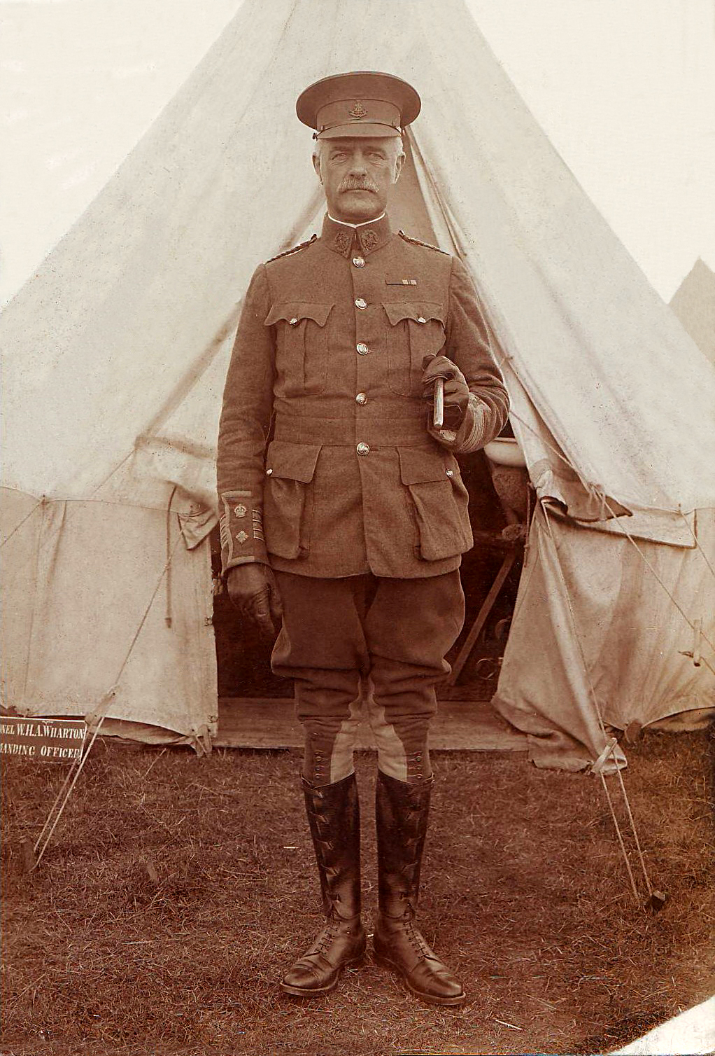
Colonel William Henry Anthony Wharton.
He is named on the East side of this map agreeing to Boundary changes between North Skelton and Lumpsey Mines.
This photograph was most likely taken at an Annual Camp prior to the First World War, when he was a Major.
He was the Commanding Officer of the local Territorial Force unit, the 4th Battalion of the Yorkshire Regiment.
Luckily for him, aged 55, he was too old to go to War in 1914, as a succession of Battalion CO's were killed in the next 4 years.
While making a fortune out of mining Royalties and property rents he contributed much to Skelton. He died on the 12th December 1938, aged 79.
10th July 1874 - Skelton Castle's Unearned Income.
From the Newcastle Chronicle.
"The royalty here belongs to Mr Wharton of Skelton Castle.
It is interesting to record the fact that the projected development of the mineral resources on that Gentleman's estates by Bolckow Vaughan & Co, T Vaughan & Co, Bell Bros & Co and one or two other firms, will, within the
next 5 years, represent a total annual yield of nearly 4.5 million tons of ironstone, yielding at the average price of 6d per ton and annual royalty payment of over £100,000.
Of all the silver spoons that were ever put into men's mouths, this is surely one of the most silvery.
Because a gentleman happens to inherit a few thousand acres of land in Cleveland, he draws in addition to its agricultural rental [which is comparatively a bagatelle] an annual income of £100,000 without any risk or effort."
10th November 1884 - Mine Royalties are Not Fair and Damage British Trade.
Mr Alfred Hill, President of the Cleveland Institution of Engineers in his inaugural address and quoting the local Ironmaster, Sir I, Lowthian Bell, said:-
|
"The Cleveland ironmasters pay to the owners of coal, limestone and ironstone, for Royalties the sum of 3s 9d for every ton of pig iron made."
He went on to show that in 1883 no less than £327,481 was paid to those lords of the Mine in Cleveland alone.
In Germany and France the Royalty amounts to 6d and 8d per ton respectively and the Cleveland Ironmasters, at the German rate, are thus handicapped in the race for sales to the extent of £282,835 per annum.
There was a strong feeling in many quarters that as the Royalties for the invention of the blast furnace had passed into the possession of the people, the landowners had no right to impose what amounted to an oppressive tax on
material that was extracted hundreds of feet below ground level.
PLACES ON THE MAP THAT HAVE VANISHED.
Harker Street and Cleveland St with the New Inn at the bottom. This area was then called Skelton High Green, while the area round Back Lane with the vanished Park Street and Milbank Street was just Skelton Green.
A Gasometer is shown in the field on the North Skelton side of Claphow Rd, between the two bridges that carried the main railway line to Brotton and beyond and the spur off to North Skelton Mine.
Similarly, Sadlers Hills, opposite the entrance to South Skelton Mine, Faughfield House [Hollybush Farm], North Skelton Railway Station have all gone along with the Mines themselves.
|

Sylvester Prop Withdrawal Tool.
|
THE 'GOAFS'.
The extensive areas coloured pink on the map are where Ironstone had already been extracted and the Mine roof allowed to collapse - called in Mining terms, the 'Goafs'.
By the mid 1920s Ironstone had been virtually constantly extracted at these Mines for over 50 years.
For obvious logical reasons, as the map clearly shows, the Miners worked initially direct routes to the boundaries of their particular Mine, and then began clearing out these areas and working back to the shaft bottom.
The 'roof' was supported by heavy wooden Props, placed roughly every 5 feet or so, depending on the condition of what happened to be overhead.
These props would support a beam, called a 'baulk' to hopefully prevent the 'roof' falling in.
In later years these wooden props and baulks were replaced by Steel.
Frank Holmes reckons that he preferred the wooden ones, as you could hear them creaking if they came under too much strain.
When as much iron ore as possible had been taken out of an area and only pillars of stone, around 6 feet, remained, the props were taken out and re-used if possible.
This process, called 'drawing', a dangerous job and like much Mining activity the cause of deaths and accidents, was carried out using a Sylvester Prop Withdrawer.
A strong chain was attached to a prop and cranked back with a long lever causing the links to be held on cogs - see picture.
|
SUBSIDENCE.
The constant blasting over the 100 years or so of East Cleveland Ironstone Mine operations and the subsequent removal of roof supports, as described above, did cause subsidence on the surface in some parts, but, considering the millions of tons of material that were extracted, not to the extent that may be
imagined.
The fact that the roof supports were deliberately removed on a controlled small area by area basis allowed for a gradual settlement rather than sudden collapse.
There was a serious case of property damage to 17 houses in 1883 at Boosbeck and in 1897 Upleatham Hall was allowed to collapse as a result of mining.
In 1964 the local Labour MP, James Tinn, spoke in Parliament about the fact that, now the Mines had closed, there was no authority from which to claim subsidence damages.
He referred to property damage at Loftus in 1962 and at North Skelton in 1964.
This latter instance, in which Dorman Long and Co, the local Mine owners, paid for repairs, but denied any legal responsibility, is the only reported case of subsidence due to Mining in Skelton that I have found.
There may have been many minor cases, but nothing, seemingly, of disastrous, newsworthy proportions.
It is ironic that since the closure of the Ironstone Mines, subsidence problems in East Cleveland have not been the result of underground roof collapse, but the mistaken use in some property foundations of shale from the Mine waste tips .
Of course subsidence can result from many other causes and property owners may have been tempted to 'try it on' and recoup repair costs from the rich mine owners, when they were not in fact responsible.
This seems to have been the case in the following story, kindly contributed by Howard Wilson of the Skelton History Society, courtesy of Chris Twigg of the 'Our Industrial Heartland' website.
In June 1919, Bolckow and Vaughan & Co, the owners of North Skelton and Longacre Mines received the following letter -

The properties in question were in fact Nos 39 and 41 High St and Mr Petch received the following reply -

Bolckow and Vaughan's inspector produced the following report -

A Mr Hedley of Eston Mines produced the following diagram, showing that, in fact, no Mining had taken place below Skelton High Street -

|
UNDERGROUND GRADIENTS.
The Map below should be read in conjunction with this diagram of Mine depths.

The Main Iron Ore seam dipped beneath East Cleveland in a saucer shape and in many areas there were steeper gradients underground than there were on the surface.
For instance, North Skelton Mine was 500 feet deeper than South Skelton - in local terms about the same climb as from Saltburn beach to the top of Warsett Hill.
When the raising of stone ceased at Longacre Mine, iron ore tubs were lowered underground by gravity on a cable to North Skelton shaft bottom.
Miners often had a long hilly hike from their homes to the pit head and could then have to walk uphill again underground some distance to their place of work; in the old days for a 10 hour shift and only
a bait box and cold tea to sustain them
|
|